


รวยริน เพ็ชรสลับแก้ว
โครงการปัญญาชนสาธารณะแห่งเอเชีย
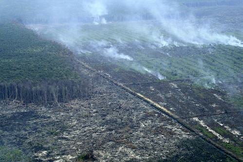
เผาป่าพรุ – สภาพความเสียหายของป่าพรุตรีป้าในอาเจะห์ ประเทศอินโดนีเซีย ที่ถูกบริษัทข้ามชาติบุกเข้าไปเผา เตรียมที่ดินปลูกปาล์มน้ำมัน
(ภาพโดย Junaidi Hanafiah)
ฤดูฝนที่อาเจะห์ปีนี้ มาช้าเกินกว่าที่ต้นข้าวในนาจะรอไหว ทุ่งนาข้าวที่อยู่ห่างไกลแหล่งน้ำ พากันแห้งตายไปต่อหน้าต่อตาชาวนา ซึ่งทำอะไรไม่ได้นอกจากปล่อยให้เป็นเรื่องของชะตากรรม
ฝนตกลงมาอย่างหนักไม่ลืมหูลืมตา เหมือนจะลืมไปว่าเมื่อวานร้อนแค่ไหน พอถึงวันถัดไปอากาศก็กลับมาร้อนเช่นเดิม เหมือนฝนไม่เคยตกลงมาเลยเป็นปีๆ อากาศร้อนสุดๆ ฝนตกหนักสุดๆ สลับกันแบบนี้เกือบทุกวัน กลายเป็นเรื่องปกติของดินแดนแถบเส้นศูนย์สูตร
แม้ว่าหลายคนจะบ่นพึมพำถึงฝนที่เทลงมาเหมือนจงใจแกล้ง ทำให้การเดินทางไปไหนมาไหนไม่สะดวก แต่อย่างน้อยก็ทำควันไฟบนเทือกเขาบูกิตบาริซานจางลงไปมากที่เดียว ถึงกระนั้นก็ยังมีให้เห็นอยู่บ้างเล็กน้อย
บริเวณเทือกเขาสูงส่วนใหญ่เป็นการเผาป่าเพื่อเตรียมเพาะปลูกในฤดูกาลใหม่ แต่การเผาป่าที่ส่งผลกระทบอย่างมากนั้น จะอยู่ในบริเวณป่าพรุ ซึ่งเป็นบริเวณที่ถูกไฟไหม้มากที่สุดถึง 97% ของพื้นที่เกิดไฟป่าในอินโดนีเซีย (Gellert K. Paul. (1998). A Brief History and Analysis of Indonesia’s Forest Fire Crisis. Indonesia, 65, 63–85.)
เกือบทั้งหมดล้วนเป็นไฟป่าที่เกิดจากฝีมือมนุษย์ อันเป็นลักษณะร่วมของประเทศกำลังพัฒนาในเขตร้อนส่วนใหญ่ ที่ต้องการบุกเบิกที่ดินทำแปลงเกษตร เพื่อปลูกพืชเชิงเดี่ยวขนาดใหญ่ ซึ่งหนึ่งในนั้นคือ ปาล์มน้ำมัน
ไฟป่า แบ่งเป็น 3 ชนิด ตามลักษณะของเชื้อเพลิงที่ถูกเผาไหม้ ได้แก่ ไฟใต้ดิน ไฟผิวดิน และไฟเรือนยอด
ไฟใต้ดิน (Ground Fire) คือไฟที่ไหม้อินทรียวัตถุที่อยู่ใต้ชั้นผิวของพื้นป่า เกิดขึ้นในป่าบางประเภท โดยเฉพาะอย่างยิ่งป่าในเขตอบอุ่นที่มีระดับความสูงมากๆ อากาศหนาวเย็นทำให้อัตราการย่อยสลายอินทรียวัตถุต่ำ จึงมีปริมาณอินทรียวัตถุสะสมอยู่บนหน้าดินแท้ (Mineral soil) ในปริมาณมาก และเป็นชั้นหนา
ในบริเวณที่ชั้นอินทรียวัตถุหนามาก ไฟชนิดนี้อาจไหม้แทรกลงไปใต้ผิวพื้นป่า (Surface Litter) ได้หลายฟุต และลุกลามไปเรื่อยๆ ใต้ผิวพื้นป่า ในลักษณะคุกรุ่นอย่างช้าๆ ไม่มีเปลวไฟ และมีควันน้อยมาก จึงเป็นไฟที่ตรวจพบ หรือสังเกตพบได้ยากที่สุด และเป็นไฟที่มีอัตราการลุกลามช้าที่สุด แต่เป็นไฟที่สร้างความเสียหายให้แก่พื้นที่ป่าไม้มากที่สุด เพราะไฟจะไหม้ทำลายรากไม้ ทำให้ต้นไม้ใหญ่น้อยทั้งป่าตายในเวลาต่อมา ยิ่งไปกว่านั้น ยังเป็นไฟที่ควบคุมได้ยากที่สุดอีกด้วย
ไฟใต้ดินโดยทั่วไป มักจะเกิดจากไฟผิวดิน แล้วลุกลามลงใต้ผิวพื้นป่า แบ่งออกเป็น 2 ชนิดย่อย คือ
ไฟใต้ดินสมบูรณ์แบบ (True Ground Fire) คือไฟที่ไหม้อินทรียวัตถุอยู่ใต้ผิวพื้นป่าจริงๆ ดังนั้นเมื่อยืนอยู่บนพื้นป่า จึงไม่สามารถตรวจพบไฟได้ ต้องใช้เครื่องมือพิเศษ เช่น เครื่องตรวจจับความร้อน เพื่อตรวจหาไฟชนิดนี้ ตัวอย่างที่เห็นได้อย่างชัดเจนของไฟใต้ดินสมบูรณ์แบบคือ ไฟที่ไหม้ชั้นถ่านหินใต้ดิน (Coal Seam Fire) บนเกาะกาลิมันตันของประเทศอินโดนีเซีย ซึ่งเกิดขึ้นตั้งแต่ช่วงเกิดปรากฎการณ์ เอล นีนโญ่ ในปี ค.ศ.1982 ไฟถ่านหินดังกล่าวคุกรุ่นกินพื้นที่ขยายกว้างออกไปเรื่อยๆ สร้างความยากลำบากในการตรวจหาขอบเขตของไฟ และยังไม่สามารถควบคุมไฟได้ทั้งหมดจนถึงวันนี้
ในบางพื้นที่กว่าจะทราบว่าไฟดังกล่าวไหม้ผ่าน ก็ต่อเมื่อไฟไหม้ผ่านไปแล้วเกือบสองปี ต้นไม้ที่ถูกไฟไหม้ทำลายระบบราก เริ่มยืนแห้งตายพร้อมกันทั้งป่า สำหรับประเทศไทยยังไม่เคยพบไฟใต้ดินสมบูรณ์แบบเช่นนี้มาก่อน
ไฟกึ่งผิวดินกึ่งใต้ดิน (Semi–Ground Fire) ได้แก่ ไฟที่ไหม้ในสองมิติคือ ส่วนหนึ่งไหม้ไปในแนวระนาบไปตามผิวพื้นป่า เช่นเดียวกับไฟผิวดิน ขณะเดียวกันอีกส่วนหนึ่ง จะไหม้ในแนวดิ่งลึกลงไปในชั้นอินทรียวัตถุใต้ผิวพื้นป่า อาจไหม้ลึกลงไปได้หลายฟุต ไฟดังกล่าวตรวจพบได้ง่ายเช่นเดียวกับไฟผิวดินทั่วไป แต่การดับไฟจะต้องใช้เทคนิคการดับไฟผิวดิน ผสมผสานกับเทคนิคการดับไฟใต้ดิน จึงจะสามารถควบคุมไฟได้
ตัวอย่างของไฟชนิดนี้ ได้แก่ไฟที่ไหม้ป่าพรุบนเกาะสุมาตราและเกาะกาลิมันตัน ประเทศอินโดนีเซีย และไฟที่ไหม้ป่าพรุโต๊ะแดงและป่าพรุบาเจาะ ในจังหวัดนราธิวาส ประเทศไทย
2.ไฟผิวดิน (Surface Fire) คือไฟที่ไหม้ลุกลามไปตามผิวดิน เผาไหม้เชื้อเพลิงบนพื้นป่า อันได้แก่ ใบไม้ กิ่งก้านไม้แห้ง ที่ตกสะสมอยู่บนพื้นป่า หญ้า ลูกไม้เล็กๆ ไม้พื้นล่าง กอไผ่ ไม้พุ่ม ไฟชนิดนี้เป็นไฟที่พบมากที่สุด และพบโดยทั่วไปในแทบทุกภูมิภาคของโลก ความรุนแรงของไฟจะขึ้นอยู่กับชนิดและประเภทของเชื้อเพลิง โดยทั่วไปไฟชนิดนี้จะไม่ทำอันตรายต้นไม้ใหญ่ถึงตาย แต่จะทำให้เกิดรอยแผลไฟไหม้ มีผลให้อัตราการเจริญเติบโตของต้นไม้ลดลง คุณภาพของเนื้อไม้ลดลง ไม้มีรอยตำหนิ ทำให้ต้นไม้อ่อนแอจนโรคและแมลง สามารถเข้าทำอันตรายต้นไม้ได้โดยง่าย ไฟป่าเมืองไทยส่วนใหญ่เป็นไฟชนิดนี้
3.ไฟเรือนยอด (Crown Fire) คือไฟที่ไหม้ลุกลามจากยอดของต้นไม้ หรือไม้พุ่มต้นหนึ่งไปยังยอดของต้นไม้ หรือไม้พุ่มอีกต้นหนึ่ง ส่วนใหญ่เกิดในป่าสนในเขตอบอุ่น ไฟชนิดนี้มีอัตราการลุกลามที่รวดเร็วมาก และเป็นอันตรายอย่างยิ่งสำหรับพนักงานดับไฟป่า เนื่องจากไฟมีความรุนแรงมาก และมีความสูงเปลวไฟประมาณ 10–30 เมตร แต่ในบางกรณีไฟอาจมีความสูงถึง 40–50 เมตร
สำหรับประเทศไทย โอกาสเกิดไฟเรือนยอดเป็นไปได้ยาก เนื่องจากสภาพภูมิอากาศมีความชื้นค่อนข้างสูง ประกอบกับไม้ป่าส่วนใหญ่ลำต้นไม่มีน้ำมันหรือยาง ทำให้ติดไฟได้ง่ายเหมือนไม้สนในเขตอบอุ่น (http://scratchpad.wikia.com/wiki/%E0%B9%84%E0%B8%9F%E0%B8%9B%E0%B9%88%E0%B8%B2 เข้าถึงเมื่อวันที่ 9 ตุลาคม 2555)
เมื่อหันมาดูข้อมูลการเผาป่าพรุในอินโดนีเซีย เพื่อปลูกปาล์มน้ำมันของบริษัทข้ามชาติขนาดใหญ่จากมาเลเซีย ดูคล้ายกับข่าวไฟไหม้พรุควนเคร็ง ที่จังหวัดนครศรีธรรมราช ที่เกิดขึ้นเกือบทุกปี ล่าสุดก็ในช่วงเดือนสิงหาคม 2555 ที่ผ่านมา
เพียงแต่ขนาดความรุนแรง และอาณาบริเวณความเสียหายของไทยน้อยกว่าอินโดนีเซีย น้อยกว่ากันมากมายชนิดเทียบกันไม่ได้
ข้อมูลที่อยู่ในมือระบุว่า สำหรับปี 2555 ไฟไหม้ป่าพรุควนเคร็งกว่า 160 จุด ในพื้นที่ 5 อำเภอของจังหวัดนครศรีธรรมราช ประกอบด้วย อำเภอชะอวด อำเภอเชียรใหญ่ อำเภอร่อนพิบูลย์ อำเภอหัวไทร และอำเภอเฉลิมพระเกียรติ พื้นที่ที่ได้รับความเสียหายไม่น้อยกว่า 15,000 ไร่
ทั้งชาวบ้าน เจ้าหน้าที่จากกรมอุทยานสัตว์ป่าและพันธุ์พืช เจ้าหน้าที่มูลนิธิสาธารณกุศล รวมหลายพันนาย ทั้งในพื้นที่และจากกรุงเทพมหานครที่ระดมบรรทุกน้ำเข้าดับไฟ ทั้งทางบกและทางอากาศอย่างขันแข็ง
นายดำรง พิเดช อดีตอธิบดีกรมอุทยานแห่งชาติสัตว์ป่าและพันธุ์พืช ออกมายืนยันสาเหตุไฟป่าครั้งนี้อย่างน่าตกใจว่า เกิดจากฝีมือมนุษย์จุดไฟเผาป่า โดยมีนายทุนจากมาเลเซียใช้นอมินีเข้าบุกรุกป่าสงวนแห่งชาติ เพื่อบุกเบิกพื้นที่ทำสวนปาล์มน้ำมันและปลูกยางพารา ส่งผลให้รัฐต้องเข้าตรวจสอบเอกสารสิทธิ์ที่ดินมากถึง 550 แปลง รวมเนื้อที่กว่า 13,000 ไร่
ขณะที่นายชาย สุวรรณชาติ หัวหน้าเขตห้ามล่าสัตว์ป่าทะเลน้อย ซึ่งอยู่ในพื้นที่ป่าพรุควนเคร็ง ก็ออกมาระบุว่า มีนายทุนจากมาเลเซียเข้ามาใช้นอมินีในพื้นที่ กว้านซื้อที่ดินมือเปล่าจากชาวบ้าน ในเขตห้ามล่าสัตว์ป่าทะเลน้อยเช่นกัน (ฅ.คนแมกกาซีน, ปีที่ 7, ฉบับที่ 10 (82), กันยายน 2555, หน้า 11)
เมื่อป่าพรุเป็นพื้นที่ที่เหมาะสมกับการปลูกพืชอุตสาหกรรมอย่างปาล์มน้ำมัน จึงไม่แปลกที่ป่าพรุในประเทศอินโดนีเซีย ซึ่งมีอยู่ 20.6 ล้านเฮกตาร์ หรือ 10.8% ของผืนดินทั้งหมด อยู่บนเกาะสุมาตรามากที่สุดคือ 35% รองลงมาที่กาลิมันตัน 32% ที่ปาปัว 30% และที่สุลาเวสี 3% จะตกเป็นพื้นที่เป้าหมายของการบุกรุก เพื่อปรับเปลี่ยนสภาพนำไปใช้ปลูกปาล์มน้ำมันของทุนข้ามชาติจากมาเลเซีย
การเข้ามาของกลุ่มทุนปาล์มน้ำมัน มิได้นำมาเฉพาะไฟป่าเท่านั้น แต่ยังนำปัญหาอื่นๆ มาอีกหลากหลายปัญหา อันเห็นได้ชัดจากปัญหาที่เกิดกับป่าพรุตรีป้า บนเกาะสุมาตรา
ป่าพรุตรีป้า ตั้งอยู่ทางฝั่งปลายแหลมตะวันตกของเกาะ มีเนื้อที่ประมาณ 61,803 เฮกตาร์ ประมาณ 60% ของป่าพรุตรีป้า อยู่ในตำบลดารุลมาค์มูร์ อำเภอนากันรายา ส่วนที่เหลืออยู่ในเขตบาบาห์รอท ทางฝั่งตะวันตกของจังหวัดอาเจะห์ (http://www.scribd.com/doc/93979949/hutan-rawa-gambut
http://www.antaranews.com/berita/336634/2145-hektar-kawasan-hutan-rawa-tripa-hilang
http://www.fire.uni-freiburg.de/GlobalNetworks/PeatlandFireNetwork/Sumatera-peatland-fire-proc-Part-4.pdf)
เรื่องราวของป่าพรุตรีป้า เริ่มเป็นที่รู้จักของคนทั้งในและต่างประเทศ จากกรณีบริษัท PT. Kalista Alam ซึ่งเป็นบริษัทยักษ์ใหญ่ ได้รับการพิจารณาจากสำนักงานการสัมปทานที่ดิน หรือ HAK GUNA USAHA (HGU) (LAND CONCESSION) ให้ได้รับสัมปทานที่ดินจากรัฐบาลอาเจะห์ เพื่อปลูกปาล์มน้ำมันในป่าพรุตรีป้า ล่วงล้ำเข้าไปในเขตป่าอนุรักษ์
ถึงแม้จะมีอีก 6 บริษัท ที่ได้รับสัมปทานที่ดินในป่าพรุตรีป้า ประกอบด้วย 1. PT. Patriot Guna Sakti Abadi, 2. PT. Agra Para Citra, 3. Glora Sawita Makmur, 4. PT. Cemerlang Abadi, 5. PT. Surya Panen Subur II, 6. Dua Perkasa Lestari.
ทว่า บริษัท PT. Kalista Alam นับเป็นบริษัทที่ใหญ่ที่สุด และมีปัญหาในการเข้าไปใช้พื้นที่มากที่สุด
Irsadi Aristora (อิรซะดี อริสโตรา) ผู้ช่วยผู้จัดการองค์กรความโปร่งใสสากล (Transparency International : TI) ในฐานะแกนนำ TKPRT (Tim Koalisi Penvelamatan Rawa Tripa) (Team Coalisi Saving Rawa Tripa) เครือข่ายปกป้องป่าพรุตรีป้า เล่าที่มาที่ไปของการให้สัมปทานที่ดินในป่าพรุตรีป้ากับบริษัทปาล์มน้ำมันว่า เริ่มมาตั้งแต่ปี 1980
ปัญหาเกิดขึ้น เมื่อรัฐบาลอาเจะห์ให้สัมปทานกับบริษัท PT. Kalista Alam เข้าไปใช้ประโยชน์ในที่ดินในปริมาณที่มากเกินกว่าป่าพรุแห่งนี้จะรับไหว
“ครั้งแรกบริษัท PT. Kalista Alam ได้รับสัมปทานให้ใช้ที่ดินในป่าพรุตรีป้าแค่ 900 เฮกตาร์ ต่อมาทางบริษัทต้องการใช้ที่ดินเพิ่มอีก 700 เฮกตาร์ ท้ายที่สุดในปี 2010 บริษัทก็ประสบความสำเร็จในการร้องขอใช้ที่ดินเพิ่ม เมื่อรัฐบาลอาเจะห์ให้สัมปทานที่ดินกับบริษัทประมาณ 1,605 เฮกตาร์”
การได้รับสัมปทานที่ดินเพิ่มขึ้นมาของบริษัท PT. Kalista Alam คงจะไม่มีปัญหา ถ้าหากที่ดินที่เพิ่มขึ้นมา ไม่อยู่ในเขตป่าอนุรักษ์ ที่กำหนดให้การใช้ประโยชน์ที่ดินในเขตป่าพรุได้เฉพาะที่มีความลึก 0.5–1.5 เมตรเท่านั้น
ปัญหาก็คือ ที่ดินในป่าพรุตรีป้า ที่บริษัท PT. Kalista Alam ได้รับสัมปทานเพิ่มขึ้นมา มีความลึกถึง 3 เมตร
อันเป็นที่มาของการรวมตัวของกลุ่มองค์กรพัฒนาเอกชน และองค์กรต่างๆ ในอินโดนีเซีย ภายใต้เครือข่าย TKPRT (Tim Koalisi Penvelamatan Rawa Tripa : Team Coalisi Saving Rawa Tripa)
เครือข่ายปกป้องป่าพรุตรีป้า ประกอบด้วย Walhi Aceh (WAHANA LINGKUNGAN HIDUP INDONESIA : INDONESIA FORUM FOR ENVIRONMENT) องค์กรด้านสิ่งแวดล้อมในอินโดนีเซีย, TII Aceh (TRANSPARENCY INTERNATIONAL INDONESIA) องค์กรความโปร่งใสสากลอินโดนีเซีย, KALA (KOALISI ADVOKASI LAUT ACEH : ADVOCACY COALITION FOR ACEH SEA) กลุ่มผู้สนับสนุนการดูแลรักษาสิ่งแวดล้อมทางทะเลอาเจะห์, Green Journalis นักข่าวสิ่งแวดล้อม, YAYASAN PENA (YAYASAN PEDULI NANGGROE ACEH : ACEH CARES FOUNDATION ) มูลนิธิรักษ์อาเจะห์, Uno Itam, JKMA (JARINGAN KOMUNITAS MASYARAKAT ADAT : INDIGENOUS COMMUNITY NETWORK) เครือข่ายสิทธิชุมชนคนพื้นเมือง, YEL (YAYASAN EKOSISTEM LESTARI : ECOSYSTEM MANAGEMENT FOUNDATION) มูลนิธิการจัดการระบบนิเวศน์, Koalisi NGO HAM (NON GOVERNMENT ORGANIZATION OF HUMAN RIGHT) องค์กรพัฒนาเอกชนด้านสิทธิมนุษยชน
ความร่วมมือดังกล่าว เกิดขึ้นเมื่อปี 2009 BPKEL (BPKEL BADAN PENGELOLA KAWASAN EKOSISTEM LAUSER : AGENCY OF ECOSYSTEM MANAGEMENT LAUSER AREA) สำนักงานการจัดการระบบนิเวศน์บริเวณเทือกเขาลาอูเซอร์ ทราบข่าวความขัดแย้งในพื้นที่ป่าพรุตรีป้า จาก FOR TRUST (FORUM TATA RUANG SUMATRA : FORUM OF SPATIAL PLANNING SUMATRA) องค์กรเกี่ยวกับการวางแผนเชิงมิติในสุมาตรา และ TKPRT นำมาสู่การจับมือร่วมกันทำงานและแลกเปลี่ยนข้อมูลสภาพป่าและปัญหาที่เกิดขึ้นในพรุตรีป้า โดยมีเป้าหมายช่วยกันปกป้องและแก้ไขปัญหาที่เกิดขึ้นกับพรุผืนนี้
“TKPRT มีหน้าที่สื่อสารเรื่องราวที่เกิดขึ้นกับป่าพรุตรีป้าให้คนทั้งใน และต่างประเทศได้รับรู้ เพื่อร่วมกันปกป้องผืนป่าแห่งนี้”
ทั้งหมดเป็นคำบอกเล่าที่หล่นออกมาจากปากของอิรซะดี อริสโตรา
นั่นหมายความว่าปัญหาที่ป่าพรุตรีป้า ไม่ได้มีเฉพาะเรื่องการเผาป่าเท่านั้น
หมายเหตุ: “ความเห็นของผู้เขียนมิได้สะท้อนความเห็นของโครงการปัญญาชนสาธารณะแห่งเอเชีย มูลนิธิฯ สถาบันประสานงานกลาง และ/หรือสถาบันภาคี”
%%%%%%%%%%%%%%%%%%%%%%%%%%%%%%%%%%%%%%%%%%%
(3) Indonesian Peat Swamp Forests: A victim of oil palm industry
Ruayrin Pedsalabkaew
Asian Public Intellectual
Burning peat swamp – Damaged condition of Tripa swamp in Aceh, Indonesia as multinational companies encroach
and burn to prepare their oil palm plantations (photo by Junaidi Hanafiah)
Aceh’s Rainy Season came quite late this year. And the paddies could no longer wait for the rains. Paddies in the fields far from water supplies started to die and despite witnessing this with their own eyes, the farmers could do nothing, but to leave it to the mercy of God.
Heavy downpours fell on as if it was forgotten how scorching it was yesterday. Then, on the next day, rains stopped and heat prevailed again. So dry, it was felt like rains have never fallen here for years and years. Extreme heat and rains alternated everyday, a sort of normal course of weather in this tropical climate.
Though complaints could be heard of the heavy downpours which have made travel more difficult, but at least, they have helped to contain much of the smoke from the Bukit Barisan leaving a little amount of the smoke to come out.
Land on high plateau was being prepared for a new seasonal crop. Forest burning caused a lot of impact in places home to peat swamp forests. Up to 97% of the peat swamp forests have been subjected to burning because of forest fire in Indonesia (Gellert K. Paul. (1998). A Brief History and Analysis of Indonesia’s Forest Fire Crisis. Indonesia, 65, 63–85).
Most of the forest fires could be attributed to human beings, something common among developing nations in tropical zone. They are caused by attempts to clear up new plots of land for agriculture, particularly monocultural plantation of oil palm.
Forest fire can be divided into three categories depending on the fuel being burned including ground fire, surface fire and crown fire.
Ground fire burns underground organic material and happens in certain types of forest, particularly in high elevations of temperate climate. Cold weather slows down organic degradation leaving a thick layer of accumulated organic material on the surface, called “mineral soil”.
In area where the organic layers are thick, the fire can penetrate several feet under the surface litter and then spread throughout the underground of the forest. It slowly simmers and causes no flame. Thus, such forest fire is hard to be detected and spreads out slowest. Yet such a forest fire can cause the most destructive impact on the forest as it can destroy the tree’s roots causing both small and big trees to die. Moreover, it is a forest fire and makes it hardest to control.
Ground fire is often caused by fire underneath and spread throughout the underground and can be divided into two categories including;
The True Ground Fire is the kind of fire that burns up underground material. When such a fire occurs, it cannot be felt even though we are standing on it. A special device is needed including a thermal sensor to detect it. One of the most obvious examples of a true ground fire is Coal Seam Fire on Indonesia’s Kalimantan during the El Niño in 1982. The spread of the coal seam fire has made an attempt to identify the scope of the fire become more difficult and has made fire extinction impossible even nowadays.
In some areas, it took over two years to detect such an underground fire. By the time, the trees’ root system has been completely destroyed with the forest. In Thailand, such total ground fire has never happened.
Semi–Ground Fire is two-folded. On one hand, it spreads horizontally along the forest ground. On the other, similar to ground fire, it can spread vertically penetrating through organic material at the surface level. It can go several feet deeper. Such a fire can be easily detected like any ground fire. But to put it out, techniques to cope with ground-fire have to be applied in combination with techniques to handle underground fire.
A fire in this case is similar to fires that spread in peat swamp forests in Sumatra and Kalimantan Islands, Indonesia and forest fires in Toe Daeng and Bajao peat swamp forests in Narathiwat.
2. Surface Fire spreads along the ground burning up the forest material such leafs, dry branches, and dried fruits falling on ground and bushes. The fire is most common and can be found in any part of the world. Its severity depends on the type of fuel. Normally, this kind of fire is not harmful to trees. It may leave some wounds on the tree and slow their growth. It may degrade the wood quality, causes flaws, or weakens the trees making them vulnerable to diseases and insects. Most forest fires in Thailand belong to this category.
3. Crown Fire spreads on treetops or from a bush to a treetop or to another bush. It mostly occurs in temperate pine forests. Since it can spread very fast, it can be very harmful to forest firemen due to its extreme heat and high flames which can be as tall as 10–30 meters or 40–50 meters in certain cases.
In Thailand, crown fires are rare due to high humidity of the climate and most tree trunks here contain no oil or rubber which can be highly inflammable, like the pine trees in temperate climate. (http://scratchpad.wikia.com/wiki/%E0%B9%84%E0%B8%9F%E0%B8%9B%E0%B9%88%E0%B8%B2, accessed on 9 October 2012)
Most of the oil palm plantations in Indonesia’s peat swamp forests belong to large scale multinational companies from Malaysia. It may sound a resemblance when one thinks of forest fires in Kuan Kreng peat swamp forest in Nakhon Si Thammarat province, lately in August 2012.
But the scale and severity of forest fires in Thailand is much smaller than the ones in Indonesia.
According to available information, in 2012, the Kuan Kreng peat swamp forest was attacked by forest fire in 160 spots covering five districts of Nakhon Si Thammarat including Cha-uat, Chian Yai, Ron Phibun, Hua Sai and Chaloem Phra Kiat causing damage to not less than 15,000 rais (2,400 hectares).
Several thousands of local villagers, officers from the Department of National Parks, Wildlife and Plant Conservation (DNP) and staff members of various charitable organizations from local area and Bangkok were mobilized to use water to put out the fires from the ground and the air.
Mr. Damrong Pidet, Director General of the Department of National Parks, Wildlife and Plant Conservation (DNP) confirmed shockingly that the fires were man-made. Malaysian investors, he accused, have hired their nominees to encroach Thailand’s forest reserve to clear the forest for oil palm and rubber plantations. As a result, the state has conducted verification of more than 550 title deeds covering the area of more than 13,000 rais (2,080 hectares).
Meanwhile, Mr. Chai Suwanchat, Head Officer of the Talay Noi Wildlife Sanctuary, which is part of Kuan Kreng peat swamp forest, also came out to accuse the Malaysian investors for land-grabbing through their nominees. A lot of land inside the Wildlife Sanctuary has been purchased from local villagers (Khor Khon Magazine, Vol. 7, No. 10 (82), September 2012, p. 11).
Given its suitability for plantations including oil palm, it is not surprising that the Indonesia’s peat swamp forests which cover the area of 20.6 million hectares or 10.8% of the total area (35% in Sumatra, 32% in Kalimantan, 30% in Papua and 3% in Sulawesi) has become a target of encroachment and tipped to be converted into oil palm plantations by the Malaysian investors.
The arrival of oil palm investors has not only brought about forest fires, it has caused many other problems including those that happen with Tripa peat swamp forest on Sumatra.
Tripa peat swamp forest is situated at the end of western peninsula of the Island covering the area of 61,803 hectares. About 60% of Tripa swamp is situated in Darul Makmur subdistrict, Nagan Raya and the rest in Babahrot, Southwest Aceh (http://www.scribd.com/doc/93979949/hutan-rawa-gambut
http://www.antaranews.com/berita/336634/2145-hektar-kawasan-hutan-rawa-tripa-hilang
http://www.fire.uni-freiburg.de/GlobalNetworks/PeatlandFireNetwork/Sumatera-peatland-fire-proc-Part-4.pdf).
The case of Tripa swamp became known to inside and outside the country as PT. Kalista Alam, a big corporation has been granted land concession or Hak Guna Usaha (HGU) from the government of Aceh to carry out oil palm plantations in Tripa swamp deeper into the conservation zone.
Though six other companies have been granted land concessions including (1) PT. Patriot Guna Sakti Abadi, (2) PT. Agra Para Citra, (3) Glora Sawita Makmur, (4) PT. Cemerlang Abadi, (5) PT. Surya Panen Subur II, and (6) Dua Perkasa Lestari, but PT. Kalista Alam is the largest among all and has caused the most problems in exploiting the area.
Irsadi Aristora, Deputy Manager of Transparency International (TI), as a core member of the TKPRT (Tim Koalisi Penvelamatan Rawa Tripa) (Team Coalisi Saving Rawa Tripa) recalls that the granting of land concessions in Tripa swamp to oil palm corporations began since 1980.
The problems began when the government of Aceh has given concessions to PT. Kalista Alam to exploit the land exceeding the carrying capacity of the peat swamp forest.
“In the beginning, PT. Kalista Alam was given permission to exploit just 900 hectares, later they were given 700 hectares more. Lately in 2010, the company could successfully ask for permission to use additional land and the government of Aceh agreed to confer to them the right to exploit 1,605 hectares of forest land”.
That PT. Kalista Alam has received the right to exploit additional land shall not cause any problem, if it was not situated inside the conservation zone. In fact, according to the law, only swamp at 0.5–1.5 meters is allowed to be exploited.
The problem is the land whose exploitation permission has been given to PT. Kalista Alam inside the Tripa swamp is as deep as three meters.
That has prompted NGOs and other organizations in Indonesia to form a network called TKPRT (Tim Koalisi Penvelamatan Rawa Tripa : Team Coalisi Saving Rawa Tripa).
TKPRT is composed of Walhi Aceh (WAHANA LINGKUNGAN HIDUP INDONESIA : INDONESIA FORUM FOR ENVIRONMENT), TII Aceh (TRANSPARENCY INTERNATIONAL INDONESIA), KALA (KOALISI ADVOKASI LAUT ACEH : ADVOCACY COALITION FOR ACEH SEA), Green Journalists, YAYASAN PENA (YAYASAN PEDULI NANGGROE ACEH : ACEH CARES FOUNDATION ), Uno Itam, JKMA (JARINGAN KOMUNITAS MASYARAKAT ADAT : INDIGENOUS COMMUNITY NETWORK), YEL (YAYASAN EKOSISTEM LESTARI : ECOSYSTEM MANAGEMENT FOUNDATION), and Koalisi NGO HAM (NON GOVERNMENT ORGANIZATION OF HUMAN RIGHT).
The collaboration began in 2009 as BPKEL (BPKEL BADAN PENGELOLA KAWASAN EKOSISTEM LAUSER : AGENCY OF ECOSYSTEM MANAGEMENT LAUSER AREA) was informed of conflicts in the Tripa swamp from FOR TRUST (FORUM TATA RUANG SUMATRA : FORUM OF SPATIAL PLANNING SUMATRA) and TKPRT. It has led to collaboration and exchange of information concerning the conditions of the forest and problems inside Tripa swamp with an aim to help protect the forest and address any problems there.
“TKPRT’s mission is to keep people inside and outside the country informed of what happens in the Tripa swamp to galvanize support to protect the forest.”
This could sum up what Irsadi Aristora has to say.
It also means that among the problems that befall Tripa swamp, there is not just forest burning.
(The views of the author do not reflect those of the API Fellowships Program, The Nippon Foundation, the Coordinating Institution, and / or the Partner Institutions.)